SuperMap GIS 10i production system introduction |
SuperMap GIS 10i includes cloud GIS platforms and a variety of GIS development platforms that support PC, mobile and browser terminals to fully embrace spatial big data.
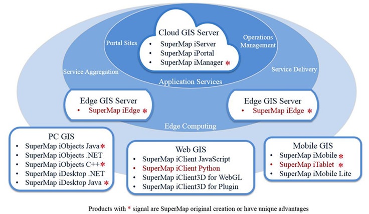
SuperMap GIS 10i product system includes GIS cloud and GIS terminals two parts, namely GIS cloud platform software, GIS terminal softwares for mobile, Web and PC. Based on the iPortal, iServer, iEdge, iManager cloud GIS platform software, provided by SuperMap GIS 10i, you can easily build a powerful, cross-platform cloud GIS service application. Based on the iMobile, iClient, iObjects, iDesktop and other types of GIS terminal products provided by SuperMap GIS 10i, you can build a variety of cross-platform client applications to connect to the cloud GIS service platform, SuperMap Online GIS platform, etc .; In addition, you can also build a more brilliant and practical real 3D applications with the new 3D integration technology which is throughout all the products of SuperMap.
Four carriages of SuperMap GIS 10i to build the GIS cloud or GIS server systems are:
A cloud GIS application server based on high-performance and cross-platform GIS kernel. It has the functions of publishing, managing and integrating the 2D&3D Integration services, and also the multi-level extension development capabilities are provided. It provides new Web services such as data catalog service, data registration, distributed analysis services, streaming service, etc., to store, process, analyze the big spatial data. And it contains Spark runtime for reducing the threshold for the deployment of big data environment. With a variety of mobile, Web, PC and other development SDK, you can quickly build spatial big data applications based on Cloud&Client Integration.
A GIS portal platform for integrating, searching, sharing and managing GIS resources, with zero code visualization customization, multi-source heterogeneous services registration, system monitoring dashboards and other capabilities. And it provides full-featured web-side applications, these fantastic applications bring you many very useful functions, such as edit your data, create professional thematic maps, browse 3D scenes, perform distributed spatial analysis, create practical dashboards for your organization, edit map style on client side and build template-based applications. What's more, as a user center, resource center and application center of the Cloud & Terminal Integration GIS platform, you can quickly build your own GIS portal site.
An edge GIS server deployed close to clients and sources of data to achieve near service publishing and real-time analytics and computing, reducing response latency and bandwidth consumption, and reducing cloud GIS center pressure. As the edge node between the GIS cloud and the application terminals, it provides proxy service aggregation and cache acceleration technology, effectively improving the terminal access experience, and provides content distribution and edge analysis and computing capabilities to help build a more efficient and intelligent "Cloud-Edge-Terminal" GIS application system.
As an comprehensive GIS operation and maintenance management center, SuperMap iManager 10i can be used for application service management, infrastructure management and big data management. It provides Docker solutions based on container technology, and can create SuperMap GIS big data sites with one-click to help you quickly deploy and experience the spatial big data services. It can monitor multiple GIS data nodes, GIS service nodes or any Web sites; it can monitor hardware resource consumption, map access hot spots, health status of nodes and other indicators; to achieve integrated operations, monitoring and management of GIS system.
The terminal GIS platform of SuperMap GIS 10i includes: PC, Web and mobile products. It can be connected to the cloud GIS platform and the SuperMap Online GIS platform. With which you can also make maps, customize your own businesses, display maps on terminals, update data, etc.
Full-featured GIS application secondary development platform for the construction of GIS stand-alone system, C/S system, providing Java, .NET, C + + and other types of API.
A plug-in desktop GIS application and development platform; a professional GIS data processing, analysis, mapping platform; Supports extension development in . NET, Java environment for rapidly customizing industry applications.
It can run on Windows and Linux systems and provides data management, data processing, mapping and other functions.
SuperMap iClient for JavaScript 10i integrates a variety of common open source map libraries, can quickly achieve beautiful, smooth map rendering and spatial analysis. And it provides functions to visualize big data and real-time streaming data. SuperMap iClient 10i for WebGL/Plugin can be used to build full-featured, high-performance cross-browser 3D GIS applications.
As a professional mobile GIS development platform, it provides 2D&3D Integration collection, editing, analysis and navigation functions, etc. The iOS and Android development kits are provided respectively.
Lightweight, fast development, free GIS mobile development kits. It supports connecting SuperMap cloud GIS platform and SuperMap cloud service, offline tile caches. The development kits for iOS and Android are provided respectively.